What map do I need??
When people head off for an adventure in the countryside, one of the first things that most will look for is a map of the area where they are heading. There are so many different options ranging from the stylised ones in guide books and leaflets through to the various types of Ordnance Survey (OS) maps available for every single square metre of Britain. There are also various more specialised maps for some areas which I will cover later. For outdoor activities, the two main types of maps that you will encounter are the OS 1;25,000 (Explorer with the orange cover) and 1;50,000 (Landranger with the red cover) editions. In some ways these are similar, and in some ways, they are very different. Which one you need primarily depends on where you are going, what activity you are doing and to a certain extent, how fast you are moving.
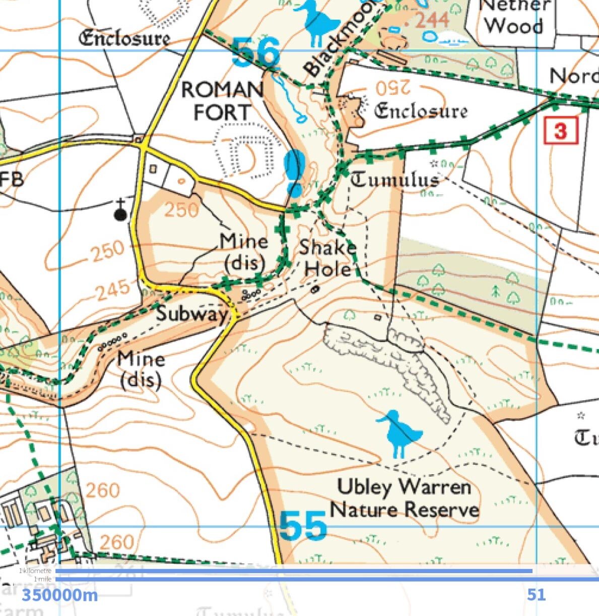
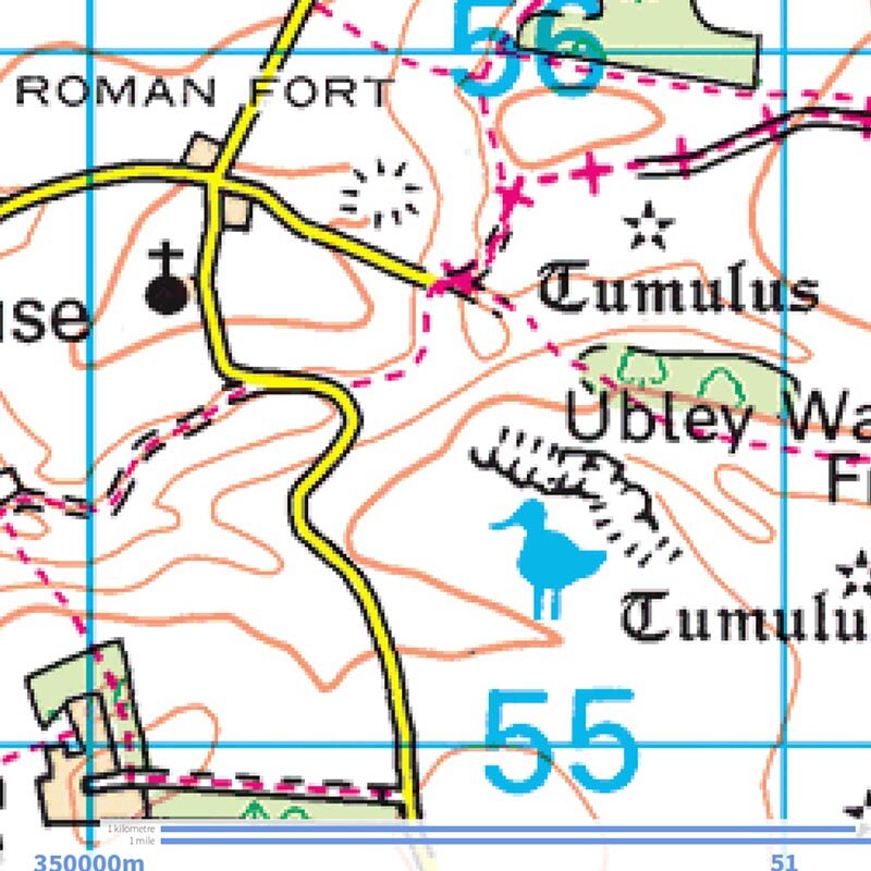
fig 1: A 1km square of the same area in OS 1:25,000 and 1:50,000 maps.
Both series/scales of maps have the same grid references (These are standardised across all OS maps of Britain) and are divided into 1km squares. The first difference you will notice is that on the 1:25,000 the squares are 4cm and on the 1:50,000 they are 2cm. For the same area on the map, the 1;50,000 map shows four times the area on the ground as the 1:25,000; this is great, but this extra coverage has to come at some cost. Shown above (fig1) is the same 1km grid square of Charterhouse on the Mendip Hills. I have adjusted them for this example so that the squares are the same size. The first this that is obvious is the increased amount of detail in the 1:25 map, on this, you can clearly see all the individual buildings, small features (such as mines and shake holes) access-land (shown shaded in yellow), a higher number of contour lines at a lower interval and most importantly, the 1:25,000 map shows detail such as walls, fences, overhead cables and small unofficial paths and tracks. For these reasons, for general walking in the countryside, the 1:25 maps are considered better as you can, for example, follow a powerline or find your path in the corner of a wall, or possibly, more importantly, see if you are actually on land where you are legally allowed. The 1:50,000 map should not be overlooked. As I said above, if your adventure involves sticking to roads and paths and is generally moving faster, then this could be the one for you. As the contours are clearer and you are not overwhelmed with information, then at speed they are much easier to use. These are generally my favourites for adventures in the bigger hills such as the Brecon Beacons and especially if I am on the mountain bike. When you look at a 1:50 map, you can see the hills and valleys more clearly, and in many situations, that's all you need to know; am I heading north, am I walking up a valley or which direction is the next summit. For these situations, these maps are perfect. Sometimes when using a 1:25 map, I will also carry a small laminate of the area in 1:50 for just these situations, where I don't need the detail and just want the bigger picture. One crucial design difference between the two maps is that on the 1:25, all of the rights of way (footpaths, bridleways, byways etc.) are shown in green whereas on the 1:50, they are shown in red. The main reason I can see for this is that if you were given an extract of a map to use or examine, you could instantly tell the scale without any other information.
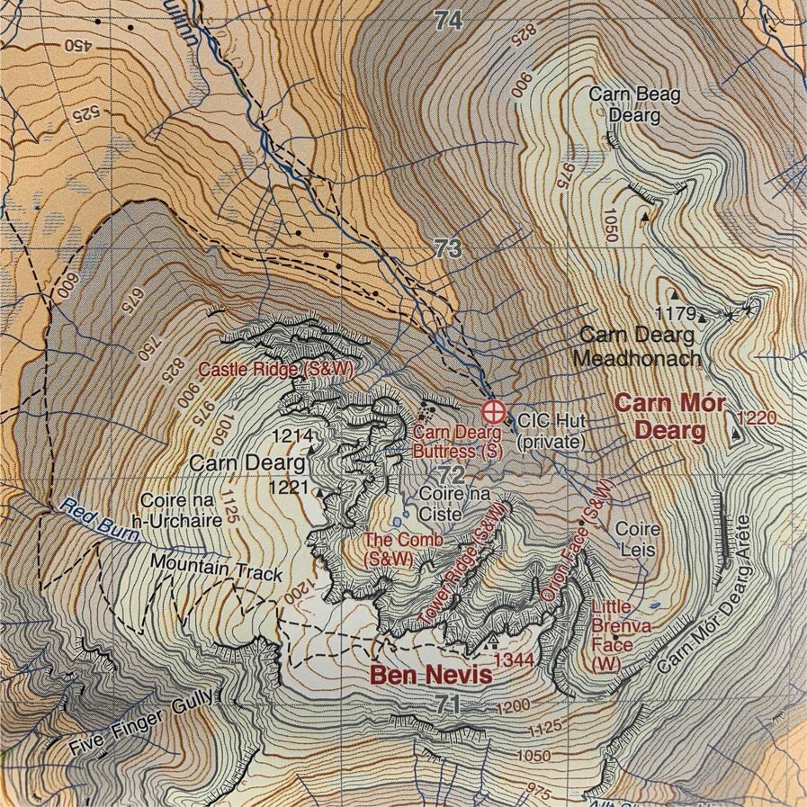
fig 2: Ben Nevis shown in th 3 common scales used in the mountains: Ordnance Survey 1;50,000, Ordnance Survey 1;25,000 & Harveys 1:40,000 British Mountain Map.
When it comes to choosing a map to use in the mountains of Britain, your requirements and choices change yet again. In fig1, I have shown extracts of the area around the summit of Ben Nevis. These are shown proportionately to each other. The new entrant to the fold is the Harveys/BMC British Mountain Map of the area. As you can see, the 1:50 gives a very clear indication of the general shape of the mountain and also clearly shows the paths and streams that are present on the hill. For general walking, as said above, this map will show you where you are, the direction you need to go in, and all the essential features for navigating a long-distance adventure either down the valleys or over the peaks, clear and straightforward is the key here. The 1:25 has much more information and shows pretty much every significant boulder, dip in the cliffs and microscopic detail in contour lines. This map would be much better suited to exploring the summits and areas away from the main routes where you need to know precisely, not just roughly what the landscape around you is like. I like these maps when I plan or expect to use micro navigation as the extra detail makes this possible. The disadvantage though (as discussed above) is all that additional detail can be superfluous and clutter up your outlook on the world and contrary to what you'd expect, make navigating quite difficult by having too much information to process.
This is where an interesting third player in the game comes in. Harvey's (in association with the BMC (British Mountaineering Council)) produce maps aimed specifically at outdoor activities in an interesting 1:40,000 scale, placing in roughly between the two OS scales. These maps do away with a lot of the information not required by their target user (such as individual rocks and specific land-use types) and replace it with clear and detailed representations of the paths as they actually are on the ground, (as well as where they should be) which has proved highly useful especially crossing Dartmoor, where most paths don't precisely follow the right route. The contours are clear every 10m with bold lines every 50m. The most noticeable difference is though that heights are also colour coded enabling you to see lowlands, valleys and summits (almost as if in 3D) by simply scanning across the map. Very useful when route planning in the field. These also show named climbing areas, especially helpful if this is why you are heading to the hill. On the flip side of this, these maps can seem a bit alien to the lifelong OS user, and for this reason, even when I'm in the hills using a Harvey's map, I will carry one of the relevant OS maps for when my brain just can't cope with things being different.